
Most of us have swerved a few wrong turns or hacked through some questionable trails and cursed the map. Most of us, though, wouldn’t spend seven years and engage dozens of experts to make a better one.
Then again, most of us aren’t Bradford Washburn. This climb-every-mountain polymath was let down by the sketchy trail maps of the Grand Canyon available in 1969. At the time, age 60 and director of the Boston Science Museum, he knew what made a good map. Washburn was the first climber to scale 20,320-foot Denali and his map of the peak is still considered the definitive map of the region. A pioneer in aerial photography, he’d go on to map Mount Everest and the Presidential Range.
But it’s his National Geographic Grand Canyon map, finally published in 1978, that illustrates his “extreme dedication to the craft of map making” says Betsy Mason, co-author of Nat Geo’s All over the Map blog. Mason previewed one of the 80 stories and showed off some of the 200 maps from forthcoming book she wrote with colleague Greg Miller titled “All Over the Map: A Cartographic Odyssey” at the recent California Map Society spring meeting.
It was the best of crowds (people who readily chime in with the correct pronunciation of “theodolite” and already grasp the merits of hachuring) and the worst of crowds (after lunch on a warm Saturday) but the story behind the Grand Canyon map kept people mostly awake and ready to push over the 45-minute session limit with questions.
Mason and Miller first started the Map Lab blog back at Wired, then moved it over to National Geographic in 2013. Mason, taken with Washburn’s Grand Canyon map the first time she saw it, went archive diving at her new employer’s and found a “huge trove of boxes” about the making of the map.

She spotted Washburn’s pitch to fund the Grand Canyon map describing the most current 1962 map (at a scale of 1 inch = 1 mile with 80-foot contour lines) as “simply inadequate” and “disturbing” for the “incredibly rough country” with “extremely intricate trails.” His map would be an “exciting addition to world cartography and one of the most magnificent cartographic challenges.”
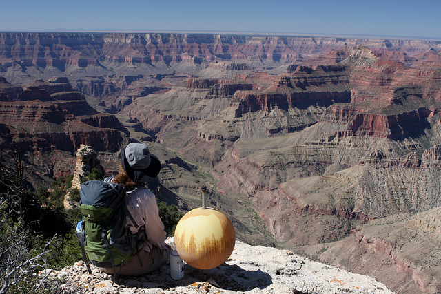
Komo Point. Washburn’s reference point – a globe core – used for aerial photography still marks the spot. Photo brewbooks on Flickr. // CC BY NC
The acceptance for his proposal was swift, but that was the only thing that happened fast. By the time Washburn and his intrepid volunteers had spent 147 days in the canyon, made over 700 helicopter landings and mapped 100 miles of trail, the original $30,000 cost had already ballooned to $100,000 (about $500,000 today, Mason says.)
“The hardest part was to come. Turning the field work into a map would turn out to be just as laborious,” Mason says. The tech and techniques involved in the Grand Canyon map are as fascinating as they are unfathomable to software-driven mappers today — for starters, translating aerial photos and surveying information into contouring sheets by hand etching them. Those sheets were then condensed into one map at a scale of 2,000 feet per inch with 50-foot contours. You’ll have to check out the book for more on the artistry of rendering the curves and dips of the canyon leading to the published version of the map, which was not a commercial success.
As map lovers who are journalists, Mason and Miller focused on digging up the stories behind the maps rather than on history or cartography. Some of the maps she previewed included pioneering neuroscientist Santiago Ramón y Cajal’s 19th-century map of the retina and Jerry Gretzinger’s map of a fictional world — 50 years in the making and counting.
You’ll be able to wrap your hands around the hardcover “All Over the Map: A Cartographic Odyssey” on October 23, 2018 — in time to put it on your holiday gift lists and make room on the coffee table.