Getting started with OpenStreetMap: Making your first edit

If you want to contribute but aren’t familiar with OpenStreetMap (OSM), here’s a tutorial to get you started. There are two quick ways to begin with OSM, you can edit the map with local information or armchair map for Humanitarian OpenStreetMap (HOT.) Either way, you’ll need to create a free account here. This LearningOSM guide is also worth a look.

Method one: Edit what you know

Once you’re logged in, choose your editor. The easiest one for beginners is iD. You’ll be asked if you want the walkthrough before editing – take it! There are more details on settings below in the humanitarian tutorial. Continue reading

Making digital maps with pen and paper: Meet Field Papers

Field Papers is a great low-tech solution for mapping. You chose an area to map, print it, walk outside with the paper copy and mark things up, then scan or take a pic of it with the QR code and it’s added as a layer to OpenStreetMap (OSM). From there you can add your data to the largest public, editable map in the world.

It’s the handiwork of venerable design firm Stamen, who later got together with U.S. Agency for International Development (USAID) for improvements. Because it’s an open-source project whose last major changes were made five years ago and many tutorials showed the previous interface, it seemed like a good idea to test drive it.

The quick slide show above shows how it works — even if you make rookie mistakes like leaving the clipboard in your photo, duh! — the test run taking about an hour total, from figuring out how to position the map to editing in OSM.

It’s been used around the world for large mapathons, where people don’t have smartphones or OSM knowledge — you hand them sheets, they go out mapping, then they hand in the sheets and they’re done. It can be a potential bottleneck for OSM data entry after collection, but surmountable. Potentially it’s also an advantage — you can get a lot of people out mapping but only need a few with OSM knowledge or who want to learn.

Geographer maps San Francisco’s bike politics

Copenhagen has a lot more in common with San Francisco than most people think, says San Francisco State geography professor Jason Henderson.

While many look to the capital of Denmark as a Nordic idyll where the drin of bicycle bells outnumbers the blare of car horns, Henderson says it went through the same political fights to get there. “It’s not a magical unique place, actually, and that opens up the doors to possibility,” says Henderson, who spent a 2016 research sabbatical in Copenhagen and has a forthcoming book about the two cities.

Speaking at a recent Nerd Nite, Henderson gave some gears to grind as San Francisco heads into June 5 elections. Politics matter – how streets are configured, how much car ownership is taxed, how much space is allocated and protected for car parking and who decides these issues – and the daily habits of politicians matter, too.

“It’s important if we’re going to have not just a bicycle city but a truly sustainable transportation city,” he says. The problem? Few San Francisco politicians are really behind the bike as a method of transportation. Continue reading

Why OpenStreetMap matters: Where did Dokdo go?

One of the rocky outcrops under dispute. Photo // CC BY NC

Battle lines have always been drawn over maps. Place names are political, cultural, temporal: from Constantinople to Istanbul and Burma to Myanmar what a place is called matters.
In the digital age, however, you have no idea who is behind the changes and why.  The companies that make the maps millions of people use every day change names following opaque processes that appear to depend on who lobbies loudest at the moment. It’s a strong argument for free, public, editable maps like OpenStreetMap where both the changes and the debate are transparent.

About a week ago, I spotted this poster petitioning Google to put Dokdo back on the map at San Francisco’s Korean American Community Center of San Francisco & Bay Area.

Continue reading

Quick preview of forthcoming book “All Over the Map: A Cartographic Odyssey”

Most of us have swerved a few wrong turns or hacked through some questionable trails and cursed the map. Most of us, though, wouldn’t spend seven years and engage dozens of experts to make a better one.

Then again, most of us aren’t Bradford Washburn. This climb-every-mountain polymath was let down by the sketchy trail maps of the Grand Canyon available in 1969. At the time, age 60 and director of the Boston Science Museum, he knew what made a good map. Washburn was the first climber to scale 20,320-foot Denali and his map of the peak is still considered the definitive map of the region. A pioneer in aerial photography, he’d go on to map Mount Everest and the Presidential Range.

But it’s his National Geographic Grand Canyon map, finally published in 1978, that illustrates his “extreme dedication to the craft of map making” says Betsy Mason, co-author of Nat Geo’s All over the Map blog. Mason previewed one of the 80 stories and showed off some of the 200 maps from forthcoming book she wrote with colleague Greg Miller titled “All Over the Map: A Cartographic Odyssey” at the recent California Map Society spring meeting.

It was the best of crowds (people who readily chime in with the correct pronunciation of “theodolite” and already grasp the merits of hachuring) and the worst of crowds (after lunch on a warm Saturday) but the story behind the Grand Canyon map kept people mostly awake and ready to push over the 45-minute session limit with questions.

Mason and Miller first started the Map Lab blog back at Wired, then moved it over to National Geographic in 2013. Mason, taken with Washburn’s Grand Canyon map the first time she saw it, went archive diving at her new employer’s and found a “huge trove of boxes” about the making of the map.

Photo brewbooks on Flickr. // CC BY NC

Continue reading

Mapping where your iPhone got lost or stolen

I am not a psychic, but I have a good idea where you and your iPhone parted ways.

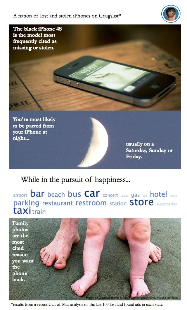
If you’re desperately seeking it on Craigslist, chances are you lost your device – or had it stolen – over the weekend, especially at night. And probably at some fun destination – shopping, the beach, a bar – or heading there on your usual means of transportation (the car, a gas station or parking lot, or bus).

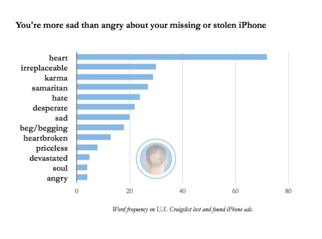
Although your entire work life might be on it, you are pleading with the person who found it (or swiped it) to return your iPhone because those photos of your dog or kid or grandma can never be replaced.

This is the most common tale to emerge from Cult of Mac’s recent analysis of hundreds of iPhone lost and found ads on Craigslist blanketing the entire United States. (Here’s the backstory on how I did it using Python, if you’re interested.)

Stealing iPhones (“Apple picking”) now accounts for about half the crimes in cities like San Francisco and New York; it’s hard to say how many absent-minded drinkers leave them at bars, but if you find a phone and don’t return it, in many places that becomes theft by finding.

Police and Apple diverge on what to do about it. The Cupertino company advises you to notify police, while some authorities are urging phone makers and service providers to add a kill switch to curb thefts.

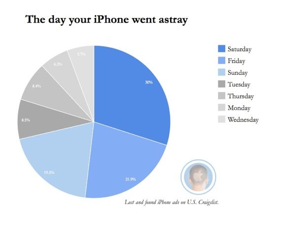
Apple’s “Find my iPhone” can help, unless the savvy crook pops out the SIM card or wipes the contents of your phone and starts over. This gray area has inspired some derring-do recoveries, like outing the thief or the finder-who-wants-to-be-keeper by staging a diabolical seduction. Not recommended.

stores

In the meantime, if you’re hoping someone will return your lost iPhone or realize they’ve bought stolen goods and do the right thing, you’re probably heading to Craigslist.

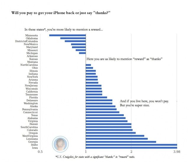
Generally speaking, you’re more likely to offer heartfelt thanks than a reward for the return of your phone. Unless you live in a place such as Washington, D.C. or Michigan, then you’re ready to bust out the cash.

After combing through these ads for the project, I bought an ugly white case for my black iPhone 4S to make it easier to see in the pitch of all of my dark bags and on taxi seats, etc. As a result, I am having fewer of those “where’s my goddamn phone?” moments.

Have you lost your iPhone? How did you recover it? Let me know in the comments.

First published at Cult of Mac.

Europe Tests a New Tsunami Monitor

Geostar, Europe\'s TsunameterAccurate, timely tsunami alert systems have proved more elusive than the Loch Ness Monster, but a new prototype testing the waters in the Atlantic may change that.

Three-ton Italian-designed Geostar (Geophysical and Oceanographic Station for Abyssal Research), set down about 150 kilometers off the coast of Portugal in the Gulf of Cadiz, has been monitoring movement and water pressure since 2008.

Geostar squats 3,200 meters below the surface on a site known for tectonic twinges — the epicenter of the 1755 Great Lisbon Quake and resulting tsunami — where researchers expect at least three or four small seismic events during testing.

Ocean bottom seismometers and pressure sensors in the station detect both quakes and changes in the height of the water column, this one-two approach may help better determine which quakes result in killer waves. Continue reading

Italian Priest Launches “Karaoke Mass” for Forgetful Parishioners

Tired of looking out on a silent congregation, a priest in Southern Italy has launched Karaoke-style mass.

Back in May, Father Antonio Russo was appointed parish priest in the church of Santa Sofia in Albanella, a town of about 6,000 some 300 kilometers south of Rome. Finding himself surrounded by mute parishioners, Don Russo decided to take action.

Santa Sofia: Where Karaoke Mass is Held

Santa Sofia: Where "Karaoke" Mass is Held

He installed a large screen near the altar that provides all the words to the liturgy plus all the verses to the songs, hoping to get some more participation. A lay person controls the Karaoke board from the pews with a remote control.

“The spirit is to get the faithful to participate,” said Don Russo. “We hope to make the church an important point of reference. ”

The battle may be an uphill one: 90 percent of Italians are baptized but only about a third are churchgoers.

Italian Inmates Work on Al Capone’s Farm

Inmates at Milan’s Opera prison work on a farm named after famed gangster Al Capone.

The name, Fattoria di Al Cappone, is a play on words from the Italian “capone” or capon, though the 15-or so men who work here raise quail and a few crops.
ivanpart

In 300 square meters on prison grounds (about 3,200 square feet), they raise the birds whose eggs are sold at a nearby Coop supermarket and a farmer’s coop, Consorzio Cascina Nibai, in the outskirts of Milan.

Launched a few months ago, the farm is the brainchild of journalist Emilia Patruno, a long-time prison volunteer whose association il due also developed the “stolen kisses” chocolates project.

Funded by a bank, before hitting the hoes inmates followed training courses given by the farmer’s coop. The group is working on a new potato, a purple Andean variety, that it hopes to patent for when the Expo comes to Milan in 2015.

Image courtesy Fattoria Al Capone.

iPhone App for Italian Soccer Games

iskySoccer fans can keep up with Champion’s League games and Italy’s Serie A games on their iPhones thanks to a free web app developed in cooperation with Sky.

Stats, line-ups, photos, and play-by-plays (for the moment, in Italian only) are available at http://i.sky.it/

The web app was developed by CEFRIEL, an ICT research hub for three Milan Universities, with a special eye to Apple-friendly design. One example: a list of team members can be rotated horizontally to a soccer field view which shows the positions they play.

A lot of men here in Italy used to carry transistor radios on Sundays listening to soccer games.

Of late, these have been replaced by videophone services that allow fans ignore wives and friends while having a stroll. The nice thing about this app is that you can keep on top of the score without ruining conversation over Sunday lunch.